.png?sfvrsn=ff199933_15)
IHPC Tech Hub
Discover the power of computational modelling, simulation and AI that brings about positive impact to your business.
- Health & Human Potential
- Manufacturing & Engineering
- Smart Nation & Digital Economy
- Transport & Connectivity
- Urban Solutions & Sustainability
Intelligent Solar Irradiation Evaluator (isolie)
Intelligent solar irradiation evaluator (isolie) is a physics-based ML-driven application with a user-friendly graphical user interface (GUI) for predicting solar irradiation in complex three-dimensional (3D) urban environments. The app can achieve near real-time execution speed for the digital twin of cities for urban planners to evaluate their urban layouts and design solar heat gain and hotspots, not just a good-to-have visualisation.
Features
- User-friendly GUI
- Parallel-computing preprocessor
- First of its kind Physics-based ML engine that only requires small training dataset
- 3D complex building geometries of arbitrary shapes and orientation are supported
- >20 cities around the world
- <10% statistical error deviation compared to numerical equivalent
- Near real-time execution speed for hundreds to thousands of urban features, i.e., buildings, solar panels
The Science Behind
Solar irradiation is a general term for the electromagnetic energy emitted from the sun for a specific duration. The amount of solar irradiation that reaches any one spot on the surface of urban environments varies according to geographic location, sky conditions, and local landscape. The physical background can be illustrated by geometrical optics, including directly radiating, diffusely radiating, and scattering. By quantifying the solar irradiation on the solar panel surfaces, the amount of electricity that can be generated from solar energy can be computed for both typical rooftop and building integrated photovoltaics.
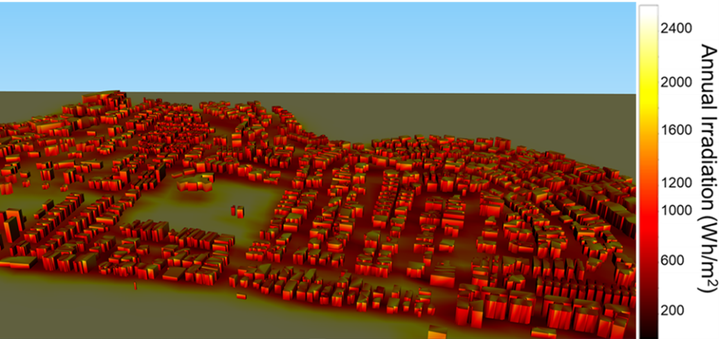
Fig 1. Solar irradiation mapping predicted by isolie for a town
Industry Applications
isolie can be applied into the following industry purposes:
- Urban planning and design
- Thermal comfort and mitigation evaluation
- Solar and Building-Integrated Photovoltaics (BIPV) planning and deployment
A*STAR celebrates International Women's Day

From groundbreaking discoveries to cutting-edge research, our researchers are empowering the next generation of female science, technology, engineering and mathematics (STEM) leaders.
Get inspired by our #WomeninSTEM