.png?sfvrsn=ff199933_15)
Urban Solutions & Sustainability
- Health & Human Potential
- Manufacturing & Engineering
- Smart Nation & Digital Economy
- Transport & Connectivity
- Urban Solutions & Sustainability
Urban Planning Assessment Tools (UPAT)
Spatial urban planning involves placing things at various locations depending on the places' social demand and economic value. Each site has its importance, typically determined by both internal and external factors. The internal factors contributing to a place's value include its potential to generate income, such as the size of the labour force, water availability, or the current level of infrastructure development (business, education or healthcare centres, etc.). Besides the internal factors, a place's value also depends on the status of others around it. A networked system where proximity and transportation among places significantly affect their values.
In collaboration with urban planners from a local company, IHPC developed an Urban Planning Assessment Tool (UPAT) that could determine suitable metrics to assess spatial locations in an urban system, considering the non-trivial relationships among these measures and the interactions among the different areas. These metrics are general and could be applied to any geographical location, so long as relevant datasets such as administrative boundaries, connecting road networks, land usage statistics within the locality, and urban parameters for each urban node are available.
The analysis helps address two key questions that are of vital interest to the planners for decision making, for example, (i) identifying the parameters that play essential roles in determining the urban status of the area; and (ii) classifying the urban nodes as either rural (having potential for future development) or urbanised (in the context of a developing country).
Features
- Illustrate the role of transport as the predominant driver of urbanisation through data analytics
- Encompass mathematical models for advanced study of urban nodes by transportation and land use
- Custom algorithms to classify the status of urban nodes by their attributes, being either rural, potential or urbanised
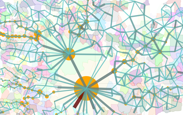
Fig 1. Network analysis to measure interconnectivity among urban nodes
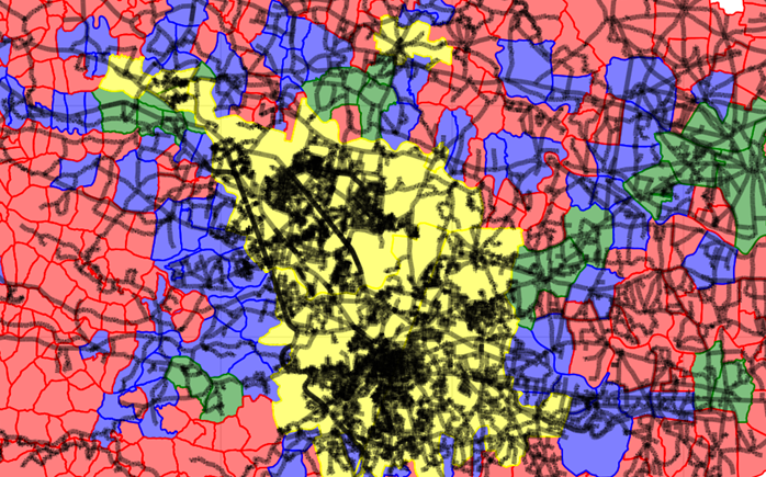
Fig 2. Classification of the urban nodes' status as either rural, having potential for future development, or already urbanised
The Science Behind
The IHPC team employed network science is employed to analyse the interconnectivity and interdependency among the components within an urban system. This analysis identifies the proper presentation of the nodes in the network and the relationships among them. A mathematical model developed by the IHPC team is then applied to this network is built to quantify the interaction among the nodes in the network and ascertaining the (relative) importance metric. This measure of importance based on network interconnectivity is then combined with other urban parameters to identify their association with urban growth and determine their development status.
Industry Applications
The methodologies developed enable urban planners to gain insights into the complex and multidimensional urban data from different sources, help to streamline and improve the overall efficiency of the planning process. The technology could potentially
be useful for private firms, statutory bodies, and other urban planning practitioners.
For more info or collaboration opportunities, please write to enquiry@ihpc.a-star.edu.sg.
A*STAR celebrates International Women's Day

From groundbreaking discoveries to cutting-edge research, our researchers are empowering the next generation of female science, technology, engineering and mathematics (STEM) leaders.
Get inspired by our #WomeninSTEM